MapFan DB Spot map databases

General facility (public)

This is a Point of Interest (POI) data set that covers the locations of General facility (public) nationwide. It is provided as point data (text format) that can be used with various GIS (Geographic Information Systems).

It covers over 200 types of facilities, including General facility (public) such as government offices, parks, and schools, as well as hospitals, leisure facilities, and accommodations.

For each facility, in addition to the name, latitude and longitude, pronunciation, address, and phone number, the map also includes "route search points" to assist in accurately guiding users to the facility's entrances and parking lots.

Furthermore, with 12 updates per year, newly opened facilities are reflected as soon as they open.

How can General facility (public) spot data transform your business? We present specific use cases and examples that offer hints for solving challenges in our case studies section.

Data Details

Comprehensive information on various public facilities nationwide

Comprehensive information on various public facilities nationwide

  • This is spot data covering the locations of General facility (public) nationwide, including government offices, schools, hospitals, leisure facilities, and accommodations.
  • The data is categorized into approximately 200 diverse genres, allowing you to extract information according to your purpose.

Abundant attribute information

  • Each facility includes basic information such as its name, latitude and longitude, address, and telephone number.
  • The facility name is available in Japanese, English, Chinese (traditional and simplified), and Korean.
  • It also includes entrance points (route search points) for each facility, enabling navigation guidance of car navigation quality.
Options are also available for "common names" and "abbreviations"

Options are also available for "common names" and "abbreviations"

  • We can optionally provide a "Multiple Facility Name Data" file containing nicknames, alternative names, and abbreviations for the facility.

Why not try using GeoTechnologies' MapFan DB?

Expected usage

    • It can be widely used for general facility searches in location-based services and products, including car navigation products and digital map services.
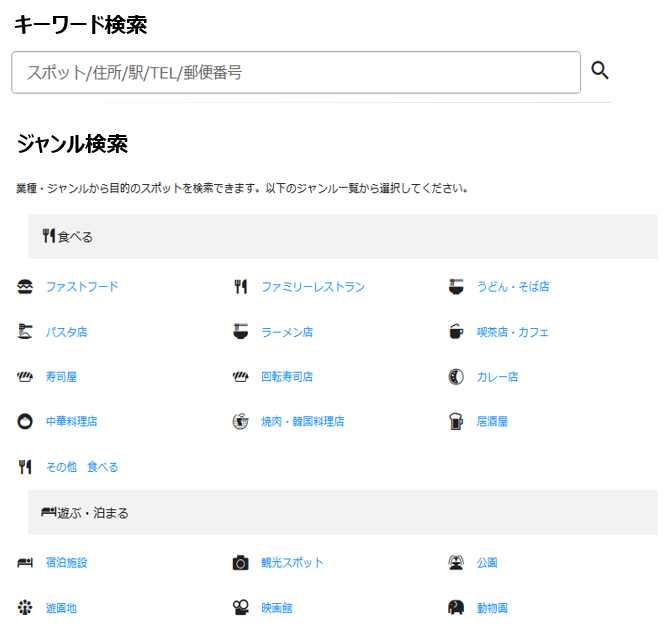
    • It supports various facility search functions, including free word search, name search, phone number search, and genre search.
    • In addition to its search function, it can also be used for marketing activities that combine it with your existing statistical and market data, such as various market area analyses and behavioral analyses.
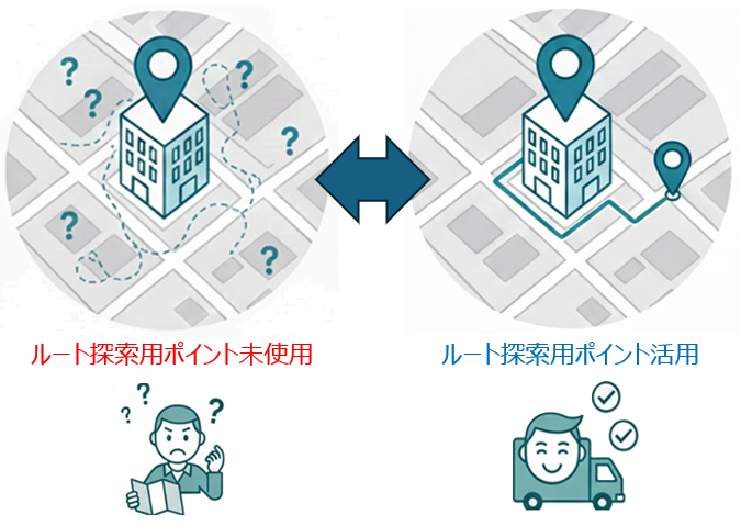
    • By utilizing the "route search point data" included in General facility (public) spot data, it becomes possible to correctly guide and direct users to facility entrances, exits, and parking lots, contributing to the resolution of the following business challenges and the enhancement of value.

    – Reducing driver stress:

    Drivers can reach the destination's parking lot or entrance smoothly and safely without getting lost, improving user satisfaction.


    – Streamlining logistics and delivery operations

    Because it can accurately guide vehicles to the entrance of the delivery destination, it directly leads to shorter delivery times and increased efficiency. By reducing misdirection and waiting times on surrounding roads, it optimizes logistics costs and improves delivery quality.


    – Improving the "quality" of the navigation function

    This solution addresses issues that directly impact the user experience, such as "I arrived but couldn't find my destination" or "I was directed to the back entrance."

    • Usage examples in destination searches (genre searches and keyword searches)

    • Usage examples for "nearby search"

FAQ

How often is General facility (public) spot data updated?

It's 12 times a year.
We continuously collect information on changes at facilities from a variety of sources, including newspapers, local government newsletters, websites, and on-site surveys. Based on the collected information, spot data is updated monthly. Newly opened facilities are also reflected as quickly as possible.

What kind of data is point data for route searching?

This data shows the most suitable destination for guiding vehicles to a facility. The appropriate location varies depending on the facility, such as a facility-specific parking lot or the road right in front of the entrance.

What kind of data is named segmentation data?

Data where the name was divided by morphological analysis. You can search with short words.
For example, spot data for "ITTOEN Museum KOSOIN" is divided into "ITTOEN/Museum/Kosoin."

Furthermore, by combining the divided words, it becomes possible to extract and analyze data based on more complex and multifaceted conditions, such as "all museums in XX (region name)" or "facilities that are XX (facility category) and contain a specific name." This improves the accuracy of detailed area marketing and target customer segment identification.

For requests for brochures or information about our services,
please feel free to contact us using the form below.
​