What is "Road Network Data?" The present and future of road network data, a crucial component of routing functions


Digital maps have become a normal part of our everyday lives. But did you know that these digital maps handle information we can’t see, and in ways we don’t notice?
With paper maps, all you see is all there is, but digital maps are different. Even for a single road, there are various forms of available data, such as speed limits, and whether or not it’s a one-way road or a road you can’t enter. There are many other forms of data that you would otherwise only find when you get to your destination. The features that we’re familiar with, such as routing, are made available to us through the maintenance of large volumes of data.
In this article, we cover information on road network data, which are crucial for creating digital maps. We talked to Mr. Suzuki and Ms. Watanabe of the Tohoku Development Center of Increment P, a company that maintains digital maps.
What is Road Network Data?
— What exactly is road network data?
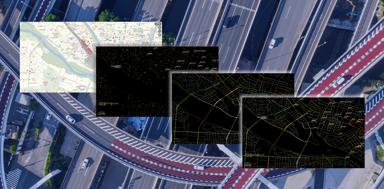
— Road network data is composed of points (road nodes) and lines (road links). This data is used mostly for navigation for driving and walking. What we call road network data is different from a visible map, in that it includes all the data on traffic regulations, intersections, and other data used when using the routing feature of maps.
— Why do we need road network for routing?
― When searching for routes using a car navigation system or your smartphone, if there’s no data about things like one-way traffic restrictions and blocked turns, you may end up following a route that you can’t actually travel through. This is why maintaining road network data is so important for routing features.
In addition to showing you whether or not you can go on a specific route, at Increment P, we classify national and prefectural roads to show you the easiest roads to travel on, and rank road levels for our routing feature. When using digital map services, you’ll often be guided on routes that will take you down narrow roads that are difficult to drive through. To solve problems like this at Increment P, we use rankings for our routing feature, which allows us to provide users with better, more optimized routes. For example, if you’re trying to get to a destination somewhere in your neighborhood, you may want to take the shortest route. It’s important to maintain large volumes of information for the road network data in order to allow users to search for the best routes by taking various conditions into account.
Our use of road rankings allows the navigation software to prioritize “wide roads” if safety is important, or the shortest distance if it’s an urgency, and so on.

Mr. Suzuki (left) and Ms. Watanabe (right) of Tohoku Development Center of Increment P
The basic structure of road network data
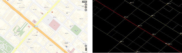
— Road network data includes various kinds of data, but how is everything visualized on a map?
― First, the background material is overlaid on the data editing screen. Then, the center of the road area is traced to create the shape.
Next, if the inbound and outbound lanes are physically separated by a structure, they’re represented using two lines joined together: one for the inbound lane and the other for the outbound lane (for dual carriageways).
If the inbound and outbound lanes aren’t separated, and are divided only by a white line in the middle, the road is represented by a single line (for two-lane roads).
By creating the shapes of road networks based on on-site structures in this way, we can offer a more precise display of the vehicle’s location, and a more accurate routing feature during navigation guidance.
Example of a two-lane road: Tsukisamu-dori, Hokkaido

Example of a multi-lane road: Near Sapporo Second Government Building
— What kind of data is included in road network data?
― For road links (lines), we include various types of data, such as road categories, like national and prefectural roads, as well as traffic regulations, road width, and the number of lanes. For road nodes (points), we maintain various data, such as traffic lights and the intersection names. At the bifurcation points, we also provide direction guide and lane information depending on the direction you’re headed in. Road network data even includes such data information on structures, like tunnels and railroad crossings, as well as road regulation sign information, like stop signs and caution signs.

Figure: Structure of road networks

Road network data: How nodes (left) and links (right) are visualized
― It seems that road network data, including traffic regulation information must be error-free for optimal routings. How do you ensure that the data is error-free?
― For information on traffic restrictions, for example, we make sure to incorporate the information retrieved from local sites into the data. In addition, to ensure that unverified information isn’t being incorporated, visual checks are performed by operators, and systematic checks are conducted on about 1,000 points of verification. Once all these conditions are met, the data is finally ready to use.
In order to find out how the on-site area changes over time, we periodically conduct road driving surveys to collect image data. This enables us to systematically extract images of specific road regulation signs from a massive repository of images taken during the driving surveys by using image recognition processing. In recent years, image recognition processing has been incorporating deep learning to make data maintenance more reliable and efficient.
The use of road network data and its future
― It seems that by maintaining such an extensive collection of data, there is a variety of uses beyond the way maps have traditionally been used. For example, road network data is crucial in routing, but what other uses do you see for this data in the future?
― The emergence of ADAS (advanced driver-assistance systems) has brought us closer to fully automated driving, and with that, we’re seeing more and more driver assistance features. One example of this technology that has already been implemented is the use of stop sign data, which is used to alert drivers in advance when they’re approaching a stop sign. In addition, traffic regulation data is being used to alert drivers when they’re exceeding the speed limit.
With regard to restrictions on large vehicles, the demand for the transport of goods is increasing due to the Covid-19 pandemic. Some places have restrictions that block vehicles carrying hazardous materials from entering certain routes. There are also height restrictions on vehicles for going under certain underpasses. In these cases, if the restrictions aren’t included in the data, drivers end up getting stuck.
To prevent things like that from happening, we’re working on incorporating data related to road-specific restrictions on vehicle classifications, heights, widths, transporting of hazardous materials, types of vehicles like trucks and buses, and so on.
In the past, we’ve focused mainly on underpasses and tunnels, but starting this year, we’ve started to incorporate a comprehensive range of data for areas that have restriction signs for large vehicles. Due to increasing demands, we plan to further expand our range of data maintenance going forward. By inputting road regulation sign information, we’ll be able to provide navigation guidance for transport vehicles that more accurately incorporates on-site conditions.
― Do you envision new ways of using road network data in the future?
― In recent years, most people have been using digital maps not only in car navigation systems, but also in smartphones. People will use digital maps not just to go somewhere by car, but also to get to their destination on foot after they get out of their car. The future of navigation systems and routing features will need to combine these two elements. At Increment P, we maintain two types of data: road network data for car navigation systems and pedestrian network data. By combining these two types of data, we can offer a navigation system and routing feature that takes you to your destination from door to door.
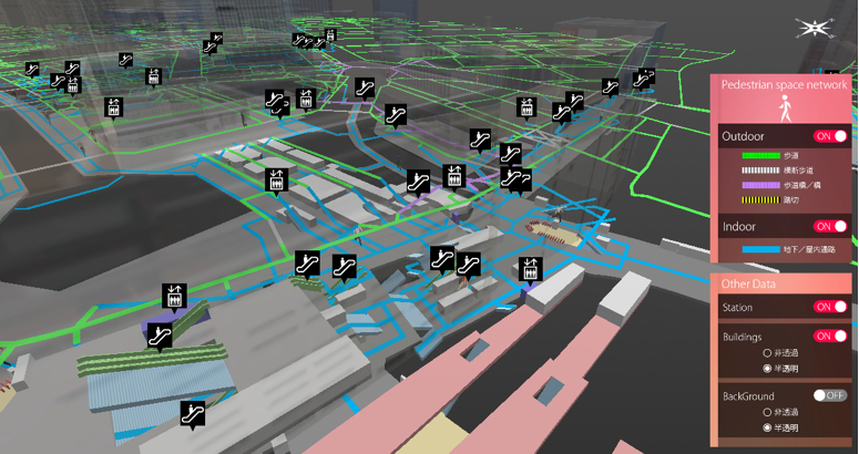
Inside Shinjuku Station: Network data provides information such as the positions of stairs and escalators
― Do you have any final comments on this topic?
― Maintaining road network data is very challenging. For newly built roads, we need to extract the shapes from diagrams and decipher them. Also, when maintaining data on traffic regulation signs, some places have unique signs that are difficult to understand and other pattern variations. When we examine the driving survey images, we sometimes find new roads that aren’t in the previously obtained diagrams. There are many things we can’t learn just from the diagrams. Especially for things like road regulation sign information (distance to destination signs and traffic regulation signs), we can’t verify them unless we look at the driving survey images. The data is finally complete after conducting the driving surveys. That being said, as difficult as the work is, there’s also a lot of joy and excitement, such as the new discoveries we make every day as we encounter various roads and road regulation signs.
We create road network data by analyzing data from various perspectives, deciphering it, verifying on-site information, and finally inputting the data. We don’t simply render road links into lines. We also create a system that can provide optimized guidance according to intersections, the number of lanes, and other on-site factors. This is where Increment P’s digital maps excel. Depending on how you use them, they can be as reliable as you need them to be.
As someone who works on creating digital maps, I want everyone to know the strengths of Increment P’s maps.
Through this report, we were able to reaffirm the future potential of road network data. The most immediate utility is in routing and navigation features. It will then be used in further optimized route guidance features, alerts generated for drivers based on traffic regulation data, and even in autonomous driving. We can imagine many uses for this technology. In addition, as the maintenance of road network data for pedestrians improves, it may become easier to identify barrier-free routes within train stations. This would help in efforts to achieve normalization, a society in which the elderly and people with disabilities can live their lives regularly without barriers.
As promising as road network data is, we also learned that maintaining this data is extremely difficult. The steady, honest work of maintaining this data will support a significant part of our lives and pave the way for a better future. To achieve this, Increment P spares no effort to carefully maintain the data step by step.
In our future article, we will introduce the types of data that have actually incorporated road network data in detail.
In this article, we featured Increment P’s road network data. You may find this road network data, which is maintained by incorporating driving survey images covering all roads in Japan, very useful for your company. If you have any questions about what this road network data can do for you, please reach out to us.
Related articles
What are “Road Driving Images?” Increment P’s driving survey images that record all roads in Japan
Contact us here
Click here to contact us for inquiries related to road network data